Discover the hidden gem of the Peruvian Andes: María Fortaleza-Taqrachullo. Nestled among breathtaking landscapes and steeped in rich history, this archaeological site offers a rare glimpse into the pre-Inca and Inca civilizations. Marvel at the unique architecture and panoramic views of three majestic canyons, and immerse yourself in the cultural significance of this extraordinary destination. Join us as we explore the enchanting beauty and profound heritage of María Fortaleza-Taqrachullo.

María Fortaleza-Taqrachullo: Encounter with History and the Majesty of the Andes

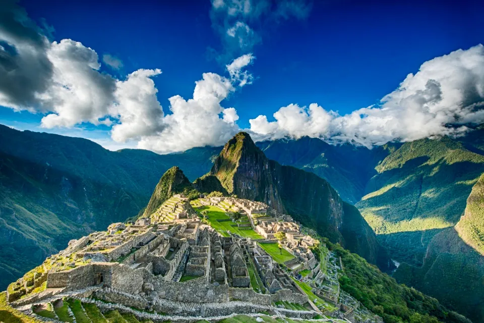
The archaeological site of Taqrachullo, also known as Maria Fortress, is hidden in the folds of the Peruvian Andes. It is a treasure of historical wealth and natural beauty. This archaeological site offers a unique window into the Inca past. It was a local human settlement, pre-Inca and Inca, with continuous occupation until the Republican era. It consists of circular, rectangular, and square constructions spread throughout the area. The Taqrachullo archaeological site is attributed to administrative functions due to its strategic location. From this place, you have a panoramic view of the three canyons and beautiful landscapes.

Suppose you are looking for a mystical destination that combines unique architecture with impressive mountain landscapes in the heights of the Andes. In that case, María Fortaleza-Taqrachullo is a new wonder in Cusco that you cannot miss. In our blog, we take you on a fascinating cultural tour where you will discover the rich history and amazing details of this place. Join us and explore this exceptional destination.

Pre-Inca Period

Before the arrival of the Incas, there were already small ethnic groups, with this being a local settlement. It became part of the Kanas ethnic group, an Aymara lordship, after the decline of the Wari culture around 1000 AD. According to 16th and 17th-century chroniclers, this territory was dominated by the Kanas and Canchis.

Inca Period

During the Inca Empire, the Kana nation integrated into Tahuantinsuyo through a confederation with the Incas, becoming privileged allies. They actively participated in battles against the Chancas and managed the administrative control of the ethnic groups on the route to Qollasuyo.

Colonial Period

In 1615, the Kana territory, with its capital in Tinta and part of the Kanas-Qanchis corregimiento under Cusco's administration, was a source of labor for the Potosi mines and Cusco workshops. The Kanas natives were sent under the pretext of the mining mita, facing mistreatment and death. The first Europeans, the Almagristas, arrived in these lands seeking "El Dorado." Failing to find it, they settled for the mining wealth. From the 17th to the 19th century, estates like Pucara and Totorani near the T’aqrachullo Archaeological Monument were developed and reused as homes and corrals by farmers.

María Fortaleza-Taqrachullo Today

Currently, María Fortaleza-Taqrachullo is located in an Andean valley, offering spectacular natural views close to the three canyons. In 2010, it was declared a cultural heritage of the nation and a Regional Conservation Area by MINAN, along with the three canyons as a Queñas forest. Today, archaeological research and restoration work are being carried out at the site by the Ministry of Culture.

The word Taqrachullo comes from two Quechua words: “T’aqra,” meaning mother rock, and “Chullo,” meaning frozen water. Together, they mean “place where water flows.”

Location

The pre-Hispanic archaeological monument María Fortaleza-T’aqrachullo is located in the Taqrachullo sector of the Chaupimayo community, within the Suyckutambo district in the Espinar province, Cusco department. This site is strategically situated in the Virginniyoc canyon, perched on a rocky cliff on the left bank of the Apurímac River's confluence. It is at an altitude of 4038 meters above sea level. The landscape is dominated by rocky slopes and green pastures extending as far as the eye can see.

Weather

The climate in María Fortaleza-Taqrachullo is typically puna region, cold and semi-dry, with a marked rainy season and a dry period. The average temperature fluctuates between 8.6 ºC and 7.2 ºC.

  • Summer Season: Starts in November and extends until April, with rain in the form of hail and snow accompanied by thunderstorms.
  • Winter Season: Begins in April and lasts until November, with no rain and bright sun. From May to July, intense frosts occur, with temperatures dropping to -10ºC and strong winds.

The best months to visit are between April and November, when the weather is more pleasant and the landscape is at its peak.

Flora and Fauna

  • Flora: The biodiversity is notable, with a mix of endemic Andean flora, including pajonales Queñas (Polylepis besseri), Tholas (Parastrephia quadrangularis), and shrubs like Chillca (Braccharis latifolia), Llaulli (Barnadesia horrida), and the unique Puyas Raimondi.
  • Fauna: The fauna includes vicuñas (Vicugna vicugna), vizcachas (Lagidium spp), Andean fox (Lycalopex culpaeus), puma (Puma concolor), taruca (Hippocamelus antisensis), and a variety of high-altitude birds like the imposing Andean woodpecker (Colaptes rupicola), canastero (Asthenes), mountain caracara (Phalcoboenus megalopterus), American kestrel (Falco sparverius), flamingos (Phoenicopterus), and grebes (Rollandia rolland), among others often seen flying over the area.

Important Sites in María Fortaleza-Taqrachullo

The María Fortaleza-Taqrachullo archaeological site is divided into four main sectors with various structures, the most representative being:

The Enclosures

There is a set of circular, semicircular, rectangular, square, and D-shaped dwellings, characteristic of the Wari culture. The D-shaped structure stands out as the ceremonial place, where an important individual was found associated with gold and silver objects. These constructions are distributed throughout the archaeological complex.

Kallanca Inka

The Kallanca is a rectangular structure that served as a meeting and lodging place. This structure was a testament to Inca community life and social organization.

The Chullpas

These are small funerary structures that reach up to a meter in height. These ancestral structures played a crucial role in the community's ritual practices, located in the central part of the archaeological site.

The Roads of Qhapac Ñan (Inca Trails)

This road system (Inca Trail) heads towards Contisuyo or Condesuyo. It starts from Cusco through the Vilcanota Sicuani Rest Espinar basin, passes through the pre-Hispanic towns of Maukallacta, T’aqrachullo, and Suycutambo, arrives in Caylloma, and finally, arrives in Arequipa.

Other Nearby Points of Interest

Don't miss exploring other nearby sites, each with its unique charm, that also offers deep dives into local history and culture.

The Three Canyons of Suykutambo: A prominent set of geological formations located in Espinar. They are characterized by their depth, with vertical cliffs ranging between 80 and 130 meters high, resulting from erosion by the Apurímac, Cerritambo, and Suykutambo rivers. This site offers spectacular panoramas of the Andean landscape and is a favorite destination for trekking enthusiasts and nature lovers.

General Tips for Visitors

Transportation Options

  • Bus from Cusco to Sicuani-Espinar: You can take a bus from Cusco to Sicuani, then another to Espinar. Buses are relatively frequent, and the journey can last around 4 to 5 hours. Another option is to take direct public transport from Cusco to Espinar, departing at 5 am and 4 pm.
  • Taxi from Sicuani to María Fortaleza-Taqrachullo: From Sicuani, you can hire a local taxi to take you directly to María Fortaleza-Taqrachullo. Ensure you agree on the price before departure, as the journey can be long and on rural roads.
  • Organized Tour: Some travel agencies in Cusco offer tours to less explored places and may include María Fortaleza-Taqrachullo as part of a travel package. This includes transportation, a guide, and sometimes meals. It is the most recommended and safest way to reach your destination.

Travel Tips

  • Always have your ID or passport handy and present it when requested by accredited staff, such as the park ranger.
  • Warm clothing: The cold can be severe at night, so it is essential to bring thick jackets, hats, scarves, and gloves.
  • Wear comfortable and suitable shoes for walking on uneven terrain, preferably trekking shoes.
  • Bring a waterproof jacket or a rain poncho in case the weather changes unexpectedly.
  • A trekking pole will be very useful for support during the hike.
  • Don't forget to bring a good camera or camcorder to capture the beauty of the landscape.
  • Prepare for variable weather by bringing layers of clothing and sun protection.

Typical Dishes of Suycutambo - T’aqrachullo District

Enjoy the cuisine of the Suycutambo district, which includes native ingredients and recipes passed down through generations.

Alpaca Chicharron: This is the traditional dish of the area, made with small pieces of alpaca meat, served with potatoes and toasted corn.

Lechon or Aycha Q’aspa is a dish made with seasoned lamb meat. Chiqchimpa with chili is placed inside the lechon. It is cooked in a clay oven similar to the one used for the wathiada. This oven is built by placing flat stones known as t’oqra at the base.

Qhaspasho Soup: The typical soup made with a tuber called qhaspasho, known as k’allpas, similar to yucca. This soup is accompanied by meat or charqui with vegetables and chuño.

Frequently Asked Questions (FAQ)

What does the name "María Fortaleza-T'aqrachullo" mean?

María Fortaleza refers to the site's resistance and defensive importance. T'aqrachullo, which means "protected place" in the local language, highlights its strategic importance in ancient times.

What types of structures can I expect to see at the site?

You can observe various types of circular, rectangular, and D-shaped dwellings. There are also panoramic views of the three canyons and the entire natural landscape.

When is the best time of year to visit the site?

The dry season, from April to October, is ideal because it has more pleasant and accessible weather, which facilitates exploration of the terrain.

Are there guides available at María Fortaleza-T'aqrachullo?

No, the site does not have guides, so it is recommended to visit the site with an organized tour that includes specialized guides. These guides are knowledgeable about the area's history and culture, providing an enriching experience.

How much time is recommended to dedicate to the visit?

A complete visit usually lasts 2 to 3 hours, which allows enough time to explore the main structures and enjoy the panoramic views.

Is an entry fee required, and are there facilities on-site?

No entry ticket is required; the site is not yet included in the tourist ticket, so access is completely free. There are no guides, sanitary facilities, or other tourist services available.

What was the importance of this site in its time?

It was a strategic point for regional defense and administration. Its location allowed control of commercial and military routes in the region.

Can I bring children to the archaeological site?

Yes, the site is accessible to children and is an excellent opportunity to educate them about history and archaeology. However, it is advisable to be prepared for walking.

What safety recommendations are there for visitors?

It is recommended that you bring sunscreen and sufficient water and wear comfortable, suitable clothing for walking. Additionally, always follow the guides and signage instructions.

Are drones allowed for photography or video at the site?

Drone use is restricted to protect the site's integrity and the privacy of other visitors. It is important to check current regulations with local authorities or site administrators.

Similar Places

Kanamarca

An archaeological site located in the Chani Kanamarca community of the Alto Pichigua district, Espinar province. This complex is 15 km northeast of Yauri's capital and about 180 kilometers from Cusco. Kanamarca is a religious, administrative center of the Kanas, a pre-Inca ethnic group that played a crucial role in the region's socio-political structure before the Inca Empire's expansion. The site is characterized by its well-preserved stone constructions, including dwellings, ceremonial enclosures, and fortifications.

Three Canyons of Suykutambo

The Three Canyons of Suykutambo are a prominent set of geological formations located in Espinar. They are characterized by their depth, with vertical cliffs reaching between 80 and 130 meters high, resulting from erosion by the Apurímac, Cerritambo, and Suykutambo rivers. This site offers spectacular panoramas of the Andean landscape and is a favorite destination for trekking enthusiasts and nature lovers.

Fortaleza de Muyoq Qawa

Mauk’allaqta is an important archaeological site located 26 km from Yauri in the Espinar province. It is characterized by its impressive architecture and strategic location at high heights. Initially, it functioned as a ceremonial and defensive center, highlighting its numerous chullpas. This site is essential for understanding the traditions and social structure of pre-Inca Andean civilizations. Its historical and cultural importance underscores the ingenuity and adaptability of ancient central Andean cultures.

Similar blogs: